Doctoral Researcher:
Lea-Sophie Höyns, AWI and University of Bremen, lea-sophie.hoeyns@awi.de
Supervisors:
- Prof. Dr. Angelika Humbert, Alfred Wegener Institute - Helmholtz Centre for Polar and Marine Research, Bremerhaven, angelika.humbert@awi.de
- Prof. Dr. Andreas Rademacher, Center for Industrial Mathematics (ZeTeM), University of Bremen, arademac@uni-bremen.de
Location:
Bremen/Bremerhaven
Disciplines:
glaciology, applied mathematics, data science
Keywords:
numerical methods, inverse problems, shape optimization, ice sheet modelling, data assimilation, satellite altimetry, WAIS instability
Motivation
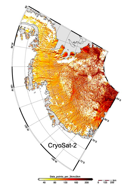
Global warming is increasingly destabilizing our earths glaciers, which in turn leads to mass loss of ice sheets and thus to a global sea level rise. The West Antarctic Ice Sheet (WAIS) is currently the major factor in the contribution of Antarctica to sea-level change. It experiences massive ice loss and is suggested to cross a tipping point leading to instability. Observations are based on satellite altimetry, which measures elevation change, that is transferred into mass loss. However, satellite altimetry retrieves only sparse surface returns in steep areas. These steep areas are located along the margins of ice sheets and thus where the mass loss is highest. Here so-called shape optimization techniques are very promising to obtain from sparse returns the ice sheet surface topography and elevation change with improved accuracy, as the physics of the system controls the form.
"However, satellite altimetry retrieves only sparse surface returns in steep areas."
In addition, the simulated mass loss for the past two decades is significantly lower than the observed mass loss. In particular the discharge is underestimated, as the glaciers and ice streams are not accelerating as quickly and as much as in reality. Using a level set function, the 3D flow field will be optimized such that the simulated level set of the surface matches the observations.
Aim
To overcome the issues that all altimetry products face so far, the PhD project aims to develop new and innovative data assimilation methods for the WAIS surface topography. In order to make use of the available amount of satellite altimetry data we implement an interface for streaming the point cloud-type altimetry data into an ice sheet model.
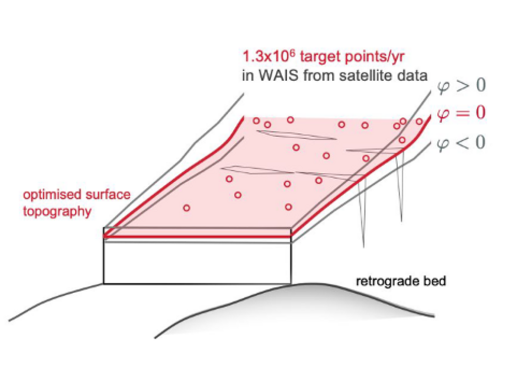
Afterwards we want to use the shape optimization approach to obtain from sparse returns a modeled ice sheet surface topography with improved accuracy over the entire period of satellite altimetry. In conjunction with the levelset front tracking we invert the forward problem to get the velocity field of WAIS. The aim is to determine the dynamic evolution (3D velocity field) of WAIS over the satellite data time period as a data product, that can serve as initial state for projections. For all these inversion strategies the ice-sheet and sea-level system model (ISSM) is applied (Larour, 2012). To identify locations of significant changes in WAIS we intent to conduct a data analysis of glaciological/mechanical side products of the optimization procedure which will serve as a basis for metrics to assess the health state of WAIS in future.
Objectives
(1) Develop an interface for streaming satellite altimetry data into the ice sheet model ISSM
(2) Extend an optimization scheme for shape optimization and a level set function in ISSM (Bondzio et al., 2016 and 2017)
(3) Conduct the shape optimization for 40+ years of satellite altimetry and generate an elevation change product (continuous function of the surface in space and time)
(4) Generate a 40 years evolution of WAIS and end in a last time step with an initial state for projections of WAIS contribution to sea level change
(5) Identify critical areas in WAIS by using the simulated physical variables of the glaciers
References
- Bondzio, J. H., Seroussi, H., Morlighem, M., Kleiner, T., Rückamp, M., Humbert, A., and Larour E. Y.: Modelling calving front dynamics using a level-set method: application to Jakobshavn Isbr, West Greenland, The Cryosphere, 10, 497-510, doi:10.5194/tc-10-497- 2016, 2016.
- Bondzio, J. H., M. Morlighem, H. Seroussi, T. Kleiner, M. Rückamp, J. Mouginot, T. Moon, E. Y. Larour, and A. Humbert (2017), The mechanisms behind Jakobshavn Isbrae’s acceleration and mass loss: A 3-D thermomechanical model study, Geophys. Res. Lett., 44, doi:10.1002/2017GL073309.
- Helm, V., Humbert, A. and Miller, H.: Elevation and elevation change of Greenland and Antarctica derived from CryoSat-2, The Cryosphere, 8, 1539–1559, 2014, doi:10.5194/tc-8- 1539-2014.
- Larour, E., Seroussi, H., Morlighem, M., and Rignot, E.: Continental scale, high order, high spatial resolution, ice sheet modeling using the Ice Sheet System Model (ISSM), Journal of Geophysical Research: Earth Surface, 117, F01 022, doi.org/10.1029/2011JF002140, 2012.
- Larour, E., J. Utke, B. Csatho, A. Schenk, H. Seroussi, M. Morlighem, E. Rignot, N. Schlegel, and A. Khazendar, Inferred basal friction and surface mass balance of the Northeast Greenland Ice Stream using data assimilation of ICESat (Ice Cloud and land Elevation Satellite) surface altimetry and ISSM (Ice Sheet System Model), The Cryosphere, 8, 2335-2351, doi:10.5194/tc-8-2335-2014.